Tracking soil erosion with Big Data
The ‘weObserve’ project developed efficient strategies enabling data analyses and evaluations on a large scale and over long periods of time.
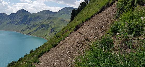
In the project, a study has been conducted in the Urseren valley, a high-alpine valley located between the well-known Oberalp, Furka and Gotthard passes, in which aerial photographs from the period between 2000 and 2016 have been analysed. Based on this the project was able to ascertain that the area covered by degraded soil increased from around 15 to approximately 40 hectares. This means that the area has more than doubled in just 16 years.
The process of soil erosion is generally very difficult to document and map. This is partly because soil erosion very often occurs in remote areas such as the Alps. In addition, soil erosion is often a very gradual process that happens virtually unnoticed. We are seeking to develop new methods for documenting and mapping soil erosion.
Automated mapping thanks to machine learning
The ‘weObserve’ project therefore developed efficient strategies enabling data analyses and evaluations on a large scale and over long periods of time. What makes the project unique was the fact that we were able to use remote sensing methods to analyse soil erosion processes – in other words, methods aimed at achieving automated mapping of aerial photographs. This enabled us to spatially and temporally document and model data, even from very remote areas. The machine learning and ‘deep learning’ methods developed enable the integration of heterogeneous datasets and expand current possibilities to include new applications on a large scale.
In addition to the study in the Urseren valley, the method was successfully applied in ten hillside-grassland-sites across Switzerland. The accuracy of the results can be further increased by taking particular conditions of different areas into consideration.
Improved understanding for a better protection
The results of ‘weObserve’ help to spatially and temporally quantify and map soil erosion. They also help to better understand the processes involved and thus also promote measures to adapt land use. This is crucial since tourism, agriculture and land use planning are all needed to protect alpine soils. Improved understanding and comprehensive documentation of soil erosion in mountain and alpine areas will enable measures to be implemented in agricultural practice.
These results are therefore also extremely relevant to the world of politics. Only what is visualized will be noticed, and only what is noticed can be incorporated into legislation and subsidy systems.
Follow-up project with the Federal Office for the Environment
The software developed as part of the NRP 75 project will now be further developed in a new research project seeking to map erosion on an extensive scale. The project will be funded by the Federal Office for the Environment and will play a major role in helping to protect soils in the Alps.